Let Us Elucidates on the Radical Speed Changes in The Heliocentric Model
Apr 23, 2024 14:13:01 #

Steven smith wrote:
Is it possible that your measurements are flawed or in some ways not accurate as you might think?
Military targeting lasers, Camera, Binoculars and my Telescope all give you a view of SEA LEVEL that's indisputable.
Apr 23, 2024 14:39:46 #
Steven smith wrote:
What fundamental forces are at work that supports you ideas about how the universe works?
You know your answer so why ask, it what you were told. Maybe your bible tells you so.
Apr 23, 2024 14:40:27 #

Ri-chard wrote:
My observations and testing show all oceans lakes and the horizons are flat and straight ahead never looking down a curve to view the horizon.

Apr 23, 2024 14:43:29 #
Apr 23, 2024 21:04:01 #
BS: They do not disappear over the horizon. Your eyesight is limited. That has been proven time and time again with cameras, binoculars and telescopes. Nice try. The seas have sea levels - not sea curves.
Planes fly in level flight - not flying down a curving spinning ball. Your false narratives are hilarious.. The pilot never looks down for the horizon - it's always straight ahead. WTFU!
All you have is CGI pics and cartoons.
Planes fly in level flight - not flying down a curving spinning ball. Your false narratives are hilarious.. The pilot never looks down for the horizon - it's always straight ahead. WTFU!
All you have is CGI pics and cartoons.
Apr 23, 2024 22:21:50 #
Ri-chard wrote:
I was in the navy, ships do actually disappear over the horizon.BS: They do not disappear over the horizon. Your eyesight is limited. That has been proven time and time again with cameras, binoculars and telescopes. Nice try. The seas have sea levels - not sea curves.
Planes fly in level flight - not flying down a curving spinning ball. Your false narratives are hilarious.. The pilot never looks down for the horizon - it's always straight ahead. WTFU!
All you have is CGI pics and cartoons.
Planes fly in level flight - not flying down a curving spinning ball. Your false narratives are hilarious.. The pilot never looks down for the horizon - it's always straight ahead. WTFU!
All you have is CGI pics and cartoons.
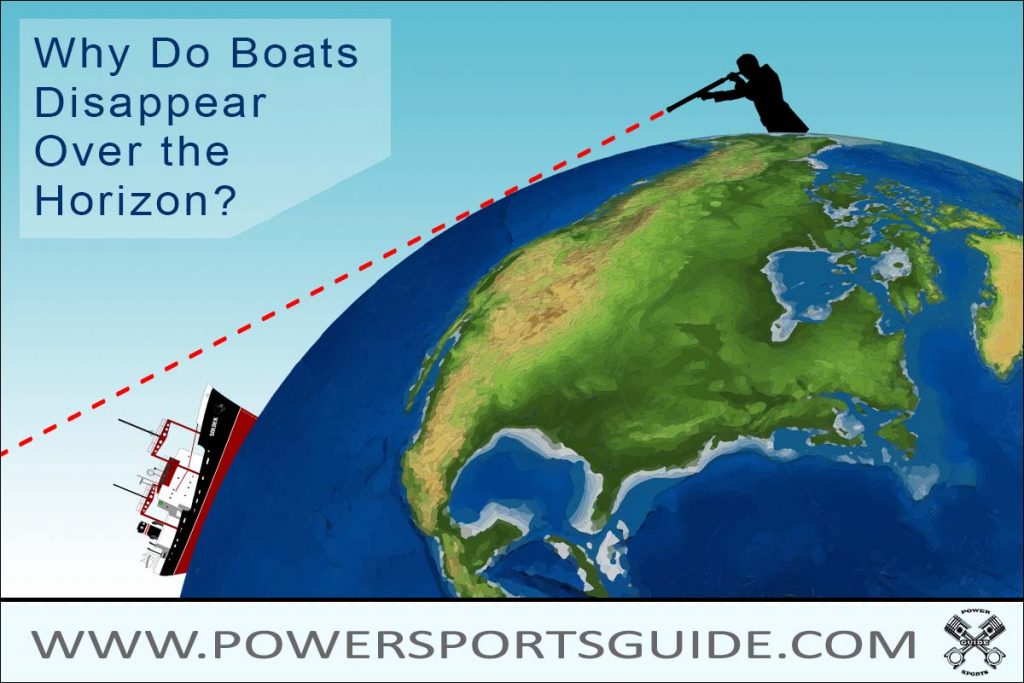
If you are on the deck 50 feet above the water, the horizon is 8.65 miles distant.
In the navy, I was an aircrewman, at 30,000 feet above the sea, ships still disappear over the horizon.
At that altitude the horizon is 212 miles distant.
For example, I was a radar operator on a navy patrol plane and, depending on circumstances, we flew our search missions anywhere between 500ft and 30,000ft. Since radar is a line-of-sight transmission, from 30,000 feet a surface target "blip" would disappear from the scope at 212 miles. Pretty simple concept to understand.
Mean sea level (MSL) is an average surface level of one or more among Earth's coastal bodies of water from which heights such as elevation may be measured. The global MSL is a type of vertical datum – a standardised geodetic datum – that is used, for example, as a chart datum in cartography and marine navigation, or, in aviation, as the standard sea level at which atmospheric pressure is measured to calibrate altitude and, consequently, aircraft flight levels. A common and relatively straightforward mean sea-level standard is instead a long-term average of tide gauge readings at a particular reference location.
In a nutshell, when speaking of sea levels, the word "level" does not mean flat.
Sea level, or the level of the sea, depends entirely on the volume of water in the sea,
i.e., the more water, the higher the sea level, and conversely, the less water, the lower the level of the sea.
Apr 23, 2024 22:57:53 #
Blade_Runner wrote:
I was in the navy, ships do actually disappear ove... (show quote)
******* I was in the navy, ships do actually disappear over the horizon.
You lie. There is no over the horizon. The horizon is always straight ahead. That's why you can always make the ship your eyes can't see reappear with optics. I probably worked on more ships than you ever deployed on. And have more air time as well.
Apr 24, 2024 14:14:28 #

Steven smith wrote:
Richard , I posted a answer to your question, did you not read it?
He might have read it, but I doubt if he truly understood what you were trying to point out. He seems to be unable to grasp the concept that the earth and everything on it are all moving as a single entity and thus everything "appears" to be at rest (i.e. relativity).
Apr 24, 2024 14:42:38 #
SeaLass wrote:
He might have read it, but I doubt if he truly understood what you were trying to point out. He seems to be unable to grasp the concept that the earth and everything on it are all moving as a single entity and thus everything "appears" to be at rest (i.e. relativity).
Just another lie. you guys believe anything the elites tell you.
You believe the Old Testament is true and accurate even though the PROOF is in total opposition that it is false..
You believe the American Patriots won the Revolutionary War/War of Independance and without proof they were the documented victors with either a Doctrine of Conquest or an American Treaty.
You guys believe the oceans and lakes curve around a spinning ball earth when it is known they are Level to the eyes and measurements. All you have to do is look at NASA's curvature rate of the earth per mile.
Apr 24, 2024 16:05:58 #
Ri-chard wrote:
Just another lie. you guys believe anything the el... (show quote)
#1 Show me why you think this, other than just assuming it is the case.
# 2 I believe that Cornwallis signed articles of surrender at Yorktown, and latter the British pulled all of their troops and government officials out of the colonies. Also a few years latter we had PRESIDENT George and a CONGRESS running the the country, not KING George and a PARLIMENT.
# 3 Come back when you have a bit better understanding of physics, particularly relativity and the Theory of Universal Gravitation.
Since I believe I have made my points on this topic clear to other readers on OPP, I'll consider this case closed. If you want to consider that as a victory, be my guest.
Apr 24, 2024 17:18:54 #
SeaLass wrote:
#1 Show me why you think this, other than just ass... (show quote)
You present no documented proof for anything you believe that you were told as a child - the proof of who was the victor is written by King George 3rd and his merry English men 1783. where is the protest from Washington, Congress and Senate? This 1783 Treaty is the only legal document under the King's Rule of Law form for how the war would end. And this stands in ever law school across America. The American Patriots lost the right to vote during the founding years. Lost the right to own their lands with free and clear title, (this stands to this date) - except for the English landowners. Lost the right to choose their Rule of Law form (the foundations of God's Laws/Natural Laws) and got the King's Rule of Law forms Maritime, Admiralty and Common Law never ending which also stands to this date. Lost the right to have a National Banking System and Currency choices - they got the King's private Banking System supported by Washington and Hamilton. (We still have a foreign banking and currency system to this date with addition of bill collectors as the Federal Reserve, IRS and SSA. The King in his Treaty even gave order to Congress for what they SHALL Do. In the introduction of the King's Treaty, he claims his capacities over the United States of America........ Not bad for the guy you believe lost the war and without any proof.
Please disprove with documented fact.
Cornwallis and Washington were both Master Masons under the Masonic Blood Oath. Could this be why Washington never took an oath to "this Constitution for the United States of America" when he was sworn in as POTUS on a Masonic Bible swearing to a false oath? (read the USA Constitution and the 1889 First Act of Congress - Oath) Cornwallis at his so-called surrender told all in attendance that the Holy War now begins 1781. There is no document stating the America won the war against King George and the British Crown stating the Americans have the right to control their own destiny and announcing the capture of ALL the spoils of war..
Please dispute with your documented facts.
Your gravity "THEORY" opposes the facts demonstrated for weight, density and buoyancy - No gravity.
Again, you present no proof as I do. You only believe what you were told as a child without having knowledge. You shall always reman a child in an adult's body.
And of course, there is the phony biblical genesis ew story that has been proved to have been plagiarized from the ancient recording s written thousands of years before a jew existed...
If you want to reply, then register here. Registration is free and your account is created instantly, so you can post right away.