To All my OPP Friends who oppose Trump's Wall
Jan 16, 2019 00:54:45 #

son of witless wrote:
I think a lot of the landowners would be happy not to have hundreds or thousands or millions of i******s crossing their properties. As far as paying them to be on the border, okay lets us use your arguments. Why would landowners who object to a wall, allow Soldiers onto their properties ?
I certainly would be happy to not have illegal crossing my property!!!!
I live on 17 plus acres surrounded by a 60 mile long federal conservation area where native rare and endangered species are tested for reintroduction to their native habitat. No hunting is allowed, so both because of remoteness and a hunting ban, hearing gunfire should be rare. I was woken up at 3:45 this morning when my dogs erupted in barking. Soon I heard gunshots coming from the river which bisects the property and which i******s use to stay hidden in the trees along it. The shooting sounded like it came from multiple weapons including more than one sounding handguns (one sounded like a 45 which is not what CBP normally uses), and a shotgun. CBP normally use, Remington 870 shotgun and the Colt M4/A1 carbine as well as 9mm Heckler & Koch P2000. I am not well versed enough to recognize the individual sounds of these weapons, but can tell a shotgun from a rifle or handgun. And a 45 is fairly distinctive. The shootout seemed to last a long time.
The night before my dogs raised a ruckus and I saw flickering lights through the trees along the river.
This sort of thing goes on far too often for my piece of mind.
Jan 16, 2019 07:18:22 #

son of witless wrote:
I think a lot of the landowners would be happy not to have hundreds or thousands or millions of i******s crossing their properties. As far as paying them to be on the border, okay lets us use your arguments. Why would landowners who object to a wall, allow Soldiers onto their properties ?
Many landowners now clash with over zealous Border Patrol agents violating their private property rights.
Troops will be another point of contention with many land owners.
I tried to research how land owners would react to troops on their private property but could find nothing. Some landowners have given Texas m*****a groups like the Patriots permission to patrol their land. The most I could find was that many landowners, whose land is directly along the Rio Grande, feel sorry for the i******s as they are in terrible shape from the long, arduous journey north, and usually give them water and food.
It does present a conundrum.
But one thing that is evident is that most of the landowners are against a border wall and are preparing to fight against it.
http://www.texarkanagazette.com/news/texas/story/2019/jan/10/texas-landowners-dig-oppose-border-wall/760324/
https://thehill.com/blogs/blog-briefing-room/news/424656-texas-landowners-preparing-to-fight-eminent-domain-over
http://newrepublic.com/article/141711/texas-doesnt-want-trumps-wall-either
Jan 16, 2019 07:48:50 #

buffalo wrote:
Many landowners now clash with over zealous Border... (show quote)
Buffalo,
While I buy the fact that many Texans feel compassion for i******s crossing the border because they are hungry, thirsty, or starving, this does not diminish the fact that the vast majority are coming to this country for economic reasons. Were it not for the fact that i******s can get medical, schooling, housing, and welfare benefits unavailable in their home country, they would not be violating our i*********n l*ws.
While there has been much ado about the waste of money to build a wall, and deniers who say it is not necessary, almost no one seems to be willing to propose alternatives to eliminate the economic incentives for i******s to enter our country. If you get rid of those incentives, then perhaps a border wall would be unnecessary (other than for keeping out drug smugglers, illegal sex trafficking, potential terrorist infiltration which everyone says can't be proven until NK, Iranian, Chineese 3rd column infiltrators are given the green light if and when hostilities break out).
But you will not hear this issues addressed by anyone other than Ron Paul. Is this because anyone proposing this would be labeled as r****t? Why would a serious discussion of "eliminating economic incentives for i*****l i*********n" be considered r****t?
Jan 16, 2019 09:01:37 #
JoyV wrote:
Building a border wall away from the border is NOT... (show quote)
Then pray tell, joyv, where in the hell would you build a damn wall? Property owners, farmers and ranchers own land right up to the banks of the Rio Grande. If my memory is correct, the US/Mexico border is defined as a line running from the deepest channels in the middle of the Rio Grande River to the first bank. Now, tell me just where in the hell is trumpy going to build his wall then.
Trumpy has no clue, as didn't bushie or his Oliness, as to the logistics of a wall between the US and Mexico, especially along the Rio Grande River. One thing is damn sure, trumpy loves eminent domain as he has used it for his real estate developments for years. THAT is fact! And the private landowners, of which there are thousands, along the Rio Grande River have vowed to fight the taking of their lands and will tie the building of a wall up in court for years.
Jan 16, 2019 09:16:56 #
ACP45 wrote:
Buffalo, br While I buy the fact that many Texans ... (show quote)
I think eliminating the economic incentives for i******s and punishing corporations that hire multiple numbers of i******s should be punished monetarily, but their decision makers from the top down should also be punished, is a great idea.
A lot of legislative action that the greedy corporate monkeys in DC pass favors their corporate organ grinders just as a lot of legislation is not passed or even considered by the DC monkeys is also for the benefit of the corporate organ grinders.
Jan 16, 2019 15:01:38 #
buffalo wrote:
I think eliminating the economic incentives for i******s and punishing corporations that hire multiple numbers of i******s should be punished monetarily, but their decision makers from the top down should also be punished, is a great idea.
A lot of legislative action that the greedy corporate monkeys in DC pass favors their corporate organ grinders just as a lot of legislation is not passed or even considered by the DC monkeys is also for the benefit of the corporate organ grinders.
A lot of legislative action that the greedy corporate monkeys in DC pass favors their corporate organ grinders just as a lot of legislation is not passed or even considered by the DC monkeys is also for the benefit of the corporate organ grinders.
Now if we can agree on this, then why can't the politicians in Washington also come to some type of understanding?
Jan 16, 2019 15:44:22 #
buffalo wrote:
Then pray tell, joyv, where in the hell would you ... (show quote)
I have answered this question several times. I'd build a wall ON THE BORDER, where it would be effective and feasible, and where i******s now cross on foot. I'd build a fence where conditions and terrain permitted. I would NOT build a wall inland from the border by more than a few feet. If a wall is not feasible AT the border, building it somewhere else makes no sense.
No to add a bit more specifics, large portions of the border in West Texas, NM, AZ, and CA a wall would be feasible and effective.
Indian nations with reservation along the border or cross border must each be met with and negotiated separately to meet their individual needs. For some a border wall might be just what they desire. For others, undesirable or even infeasible, such as the Tohono O'odham whose reservation spans the border.
Jan 16, 2019 15:51:23 #
buffalo wrote:
I think eliminating the economic incentives for i******s and punishing corporations that hire multiple numbers of i******s should be punished monetarily, but their decision makers from the top down should also be punished, is a great idea.
A lot of legislative action that the greedy corporate monkeys in DC pass favors their corporate organ grinders just as a lot of legislation is not passed or even considered by the DC monkeys is also for the benefit of the corporate organ grinders.
A lot of legislative action that the greedy corporate monkeys in DC pass favors their corporate organ grinders just as a lot of legislation is not passed or even considered by the DC monkeys is also for the benefit of the corporate organ grinders.
The courts have barred laws requiring identifying legal status for employment. So how can employers be held accountable if they hire i******s--while it is illegal for them to check on the legal status of applicants. The courts need to stop favoring the exploitation of i*****l a***ns and allow laws which require employers to verify legal status of their employees to stand.
Jan 17, 2019 07:06:52 #
JoyV wrote:
I have answered this question several times. I'd ... (show quote)
LOL! Here is part of the Boundry Treaty of 1970 between Mexico and the US concerning the designating the middle of the Rio Grande as the boundry between the US and Mexico and how they will handle changes in the river. Read and then tell me where you would build a wall and where you would build a fence and still comply with the tenants of the treaty.
ARTICLE II
In order to resolve uncertainties relating to
the sovereignty over islands and to restore to the
Rio Grande its character as the international
boundary in those locations where this character
has been lost between the Gulf of Mexico and its.
intersection with the land boundary, the contracting
states agree that:
A. Except as provided in Articles I (F),
III (B) and III (C) of this Treaty, from
the date on which this Treaty enters into
force, the international boundary between
the United States and Mexico in
the limitrophe sections of the Rio Grande
and the Colorado River shall run along
the middle of the channel occupied by
normal flow and, where either of the
rivers has two or more channels, along
the middle of the channel which in
normal flows has the greater or greatest
average width over its length, and from
that time forward, this international
TIAS 7313
12
boundary shall determine the sovereignty
over the lands on one side or the other
of it, regardless of the previous
sovereignty over these lands.
B. For the purposes of this Treaty, the
Commission shall in each case determine
the normal flows, which shall exclude
flood flows, and the average widths,
referred to in the preceding paragraph
of this Article.
C. The Commission, on the basis of the
surveys which it shall carry out as
soon as practical, shall with appropriate precision delineate the international boundary on maps or aerial
photographic mosaics of the Rio Grande
and of the Colorado River. In the
future, the Commission shall make
surveys as frequently as it may
consider justifiable, but in any
event at intervals not greater than
ten years, and shall record the
TIAS 7313
13
position of the international boundary
on appropriate maps. Each of the Governments shall bear half of the costs and
other expenses determined by the Commission
and approved by the two Governments for
the surveys and maps relating to the
boundaries.
ARTICLE III
In order to minimize problems brought about by
future changes in the limitrophe channels of the Rio
Grande and the Colorado River, the contracting states
agree that:
A. When the Rio Grande or the Colorado River
moves laterally eroding one of its banks
and depositing alluvium on the opposite
bank, the international boundary shall
continue to follow the middle of the
channel occupied by normal flow or, where
there are two or more channels, it shall
follow the middle of the channel which
in normal flow has the greatest average
width over its length.
TIAS 7313
14
B. (1) When the Rio Grande or the Colorado
River, through movements other than
those described in paragraph A of
this Article, separates from one
Contracting State a tract of land,
which might be composed of or
include islands, of no more than
617.76 acres (250 hectares) and
with an established population of
no more than 100 inhabitants, the
Contracting State from which the
tract of land has been separated
shall have the right to restore
the river to its prior position
and shall notify the other Contracting State, through the Commission,
at the earliest possible date
whether or not it proposes to
restore the river to its prior
position. Such restoration must
be made at its own expense within
a period of three years counted
from the date on which the Commission
TIAS 7313
15
acknowledges the separation; however,
if such restoration should have been
initiated but not completed within
the period of three years, the
Commission, with approval of both
Governments, may extend it for one
year. The boundary shall remain in
its prior location during the periods
herein provided for restoration of
the river, notwithstanding the
provisions of Aiticle II (A) of
this Treaty.
(2) If at the conclusion of the periods
herein provided the river has not
been restored to its prior position,.
the international boundary shall be
fixed in accordance with the
provisions of Article II (A) of
this Treaty, and sovereignty over
the separated tract of land shall,
as of that date, pass to the
Contracting state on whose side of
TIAS 7313
16
the river the separated tract is
then located. Should the contracting
State from whose territory the tract
was separated notify the other
Contracting State of its intention
not to restore the river to its
prior position, the international
boundary shall be fixed in accordance
with the provisions of Article II (A)
of this Treaty, and sovereignty over
the separated tract shall change as
of the date on which notification
is given through the Commission.
(3) When a tract of land passes from
the sovereignty of one contracting
state to the other in accordance
with paragraph B (2) of this Article,
its area shall be ascertained and
recorded by the Commission as a
credit in favor of the Contracting
State from which it was separated,
for later compensation by an equal
TIAS 7313
17
area in a natural separation of a
tract of the other Contracting
State which is not restored or in
a future rectification recommended
by the Commission and approved by
the two Governments in the same
river. The costs of such rectifycations shall be divided equally
between the Contracting States and,
upon completion, the middle of the
new channels shall become the
international boundary and the
Commission shall cancel the
corresponding credit.
C. When the Rio Grande or the Colorado River,
by movements other than those provided in
paragraph A of this Article, separates
from one Contracting State a tract of land,
which might be composed of or include
islands, having an area of more than
6l7.76 acres (250 hectares) or an
established population of more than 100
TIAS 7313
18
inhabitants, the international boundary
shall remain in its prior position and
sovereignty over the separated tract of
land shall not change, notwithstanding
the provisions of Article II (A) of this
Treaty. In such cases the Commission
shall restore the river to its prior
channel as soon as practical, equally
dividing the costs between the Contracting
States. As an alternative procedure the
Commission, with the approval of the two
Governments, may rectify the channel of
the river in the same section in which
the separation occurred, so as to t***sfer
an equal area to the Contracting State
from which the tract of land was separated.
The costs of these rectifications shall be
divided equally between the two Governments
and, upon their completion, the middle of
the new channels shall be the international
boundary, as defined in Article II (A) of
this Treaty.
TIAS 7313
19
D. The Commissioners shall exchange all
information coming to their attention about
possible or actual separation of lands as
referred to in paragraphs B and C of this
Article. The Commission shall promptly
make tbe necessary surveys and investigaI
tions in all cases of separation and
determine, in accordance with the provisions
of paragraphs B and C of this Article, which
type of separation has taken place.
E. Pending any changes in sovereignty brought
about by the application of paragraphs B
or C of this Article, each contracting
State shall extend to the nationals of
the other such facilities for t***sit
through its territory as may be necessary
to permit the use and enjoyment of
separated tracts as before the separation,
including such exemption from customs
duties and immigration procedures as may
be necessary.
TIAS 7313
20
F. When in the limitrophe reaches of the Rio
Grande and Colorado River, a part of the
channel temporarily loses its character
as the boundary by reason of the changes
contemplated in paragraphs B and C of
this Article, the international character
of the use and consumption of those waters,
in the order established under Article 3
of the Treaty of February 3, 1944, [1
] shall
not be modified.
ARTICLE IV
In order to reduce to a minimum the shifting of
the channels of the Rio Grande and the Colorado River
in their limitrophe sections, and the problems that
would be caused by the separation of tracts of land,
the Contracting States agree that:
A. Each Contracting State, in the limitrophe
sections of the Rio Grande and the Colorado
River, may protect its bank against erosion
and, where either of the rivers has more
than one channel, may construct works in
1
TS 994; 59 Stat. 1225.
TIAS 7313
21
the channel or channels that are completely
within its territory in order to preserve
the character of the limitrophe channel
provided, however, that in the judgment
of the Commission the works that are to be
executed under this paragraph do not
adversely affect the other Contracting
State through the deflection or obstruction
of the normal flow of the river or of its
flood flows.
B. (1) Both in the main channel of the river
and on adjacent lands to a distance
on either side of the international
boundary recommended by the Commission
and approved by the two Governments,
each contracting State shall prohibit
the construction of works in its
territory which, in the judgment of
the Commission, may cause deflection
or obstruction of the normal flow
of the river or of its flood flows.
Full text of the treaty:
http://www.state.gov/documents/organization/125390.pdf
Jan 17, 2019 21:16:49 #
buffalo wrote:
LOL! Here is part of the Boundry Treaty of 1970 be... (show quote)
It makes no difference. Only an I***T would try to build a border wall where our border is defined by the Rio grande river!!!! Only an I***T would build a wall well inland from the border, bisecting through private which then require private gates!!!! You persist in using this i***tic ineffective fiasco along certain portions of our border to justify refusing to build a border wall at all. Trump has NOT said he will copy Obama's border wall fiasco. Trump is NOT ignoring the areas where a wall can be effective built ON the border, to build in an area where a wall is not feasible. He is NOT ignoring the areas where a wall can be effective built ON the border to build in an area where the only i***tic solution was to build well inside our boundaries and cut through private property which for the property owners to access required individuals gates i******s can t***sverse through anyway!!!! If you want to rail against what was done, point your finger in the right direction! Trump is building the wall where it is feasible and where it is most needed.
Right now the urgency is where the highest concentration of the caravans are gathered such as the San Diego Sector. Hopefully my sector will be next as we get more illegal traffic than ALL other sectors combined!
What difference does it make what the exact wording is regarding the Rio Grande in any treaty as that is not where anyone with an ounce of sense would want to build a wall. So either it is idiocy or purposeful infringement on American's property rights. Before you take your pick, let me recap a few details.
1) Obama sued AZ for mandating EVERYONE who is arrested be checked as to legal status, and EVERYONE stopped for a traffic violation be checked, and ICE be notified and cooperated with.
2) Obama sued AZ for mandating EVERY employer verify EVERY employment applicant's legal status before hiring.
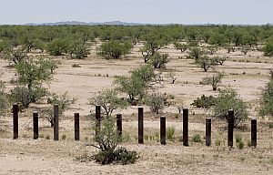
3) Obama did NOT build a wall or fence along the highest trafficked sector of the border, but in spots built vehicle barriers in the desert. [see picture]
4) Obama infringed upon American property owners by building a wall which bisected their properties which has caused inconvenience at best or great harm at worse for many property owners. This wall included many easy to access gates totally defeating the stated purpose of keeping out i******s.
5) Trump has been building a wall where the immediate crisis is the most critical, such as replacing in the San Diego Sector.
So was it due to idiocy or attacking Americans' rights?
Jan 18, 2019 08:31:58 #
JoyV wrote:
It makes no difference. Only an I***T would try t... (show quote)
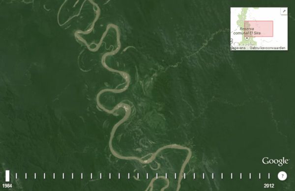
Tell me joyv, just where do you think a wall would be built in the places you rerfer to? YOU have no idea what the Rio Grande is like andhow the Rio Grande changes course over time the logistics and the topography of the Rio Grande, especially the lower Rio Grande Valley. I am not referring to the vast Big Bend area or the desert where you live. The lower Rio Grande is where most of the illegal crossing occur.
Click here and watch the river change... http://i.imgur.com/Uak4YU3.gif Then tell me where and how are you going to build a wall that is not at the mercy of the river if you don't back off sometimes miles to prevent more severe damages or cross private lands?
I contend that you may know what your talking about where you live but that you don'y know what the hell your talking about when it concerns the Rio Grand from the Gulf of Mexico to Amistad Reservoir.
Tell me, where are you going to build a fence here?
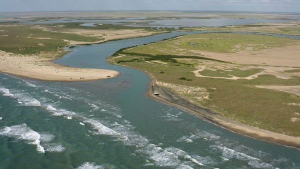
Tell me, where you gonna build a fence here that does not cross private land?
Jan 19, 2019 02:37:00 #
buffalo wrote:
Tell me joyv, just where do you think a wall would... (show quote)
Do you have a reading or a comprehension problem. I DON'T think a wall should be built in such places!!!!!!!!!!!!!! Perhaps pig latin might get through. Iay on'tday inkthey aay allway ouldshay ebay uiltay inay uchsay acesplay!
Instead, build the wall in areas where it is feasible, effective, and wanted!
Now do you understand?
Jan 19, 2019 07:13:55 #
JoyV wrote:
Do you have a reading or a comprehension problem. I DON'T think a wall should be built in such places!!!!!!!!!!!!!! Perhaps pig latin might get through. Iay on'tday inkthey aay allway ouldshay ebay uiltay inay uchsay acesplay!
Instead, build the wall in areas where it is feasible, effective, and wanted!
Now do you understand?
Instead, build the wall in areas where it is feasible, effective, and wanted!
Now do you understand?
WHERE WOULD IT BE FEASIBLE IF NOT FAR AWAY FROM THE EVER CHANGING COURSE OF THE RIO GRANDE AND REQUIRE THE TAKING BY THE GOVERNMENT OF 1000S OF ACRES OF LAND? IF YOU BUILD A WALL, OR WH**EVER, ANYWHERE IN THE FLOOD PLAIN OF THE RIVER IT WILL EITHER BE WASHED AWAY OR CAUSE MASSIVE UNINTENDED FLOODING AND DAMAGE. DO YOU COMPREHEND? I DON'T THINK YOU DO.
http://i.imgur.com/Uak4YU3.gif
Jan 19, 2019 11:08:19 #
Jan 19, 2019 11:11:47 #
nwtk2007
Loc: Texas
buffalo wrote:
WHERE WOULD IT BE FEASIBLE IF NOT FAR AWAY FROM THE EVER CHANGING COURSE OF THE RIO GRANDE AND REQUIRE THE TAKING BY THE GOVERNMENT OF 1000S OF ACRES OF LAND? IF YOU BUILD A WALL, OR WH**EVER, ANYWHERE IN THE FLOOD PLAIN OF THE RIVER IT WILL EITHER BE WASHED AWAY OR CAUSE MASSIVE UNINTENDED FLOODING AND DAMAGE. DO YOU COMPREHEND? I DON'T THINK YOU DO.
http://i.imgur.com/Uak4YU3.gif
http://i.imgur.com/Uak4YU3.gif
You DO know, don't you, that Trump and the border patrol aren't suggesting that a wall can cover each and every mile of border? However, in the areas of greatest illegal traffic, they can help funnel i******s toward points of legal entry. These additional wall/barriers are an aid to enforcement, not the end all to end all.
But of course you know that but as any good l*****t and trump h**er, you'd not like the actual t***h to be known. You simply want your win over Trump. We know.
If you want to reply, then register here. Registration is free and your account is created instantly, so you can post right away.